
Thank you for supporting this site ❤️
Make a donation
Make a donation
Braemar Hill topographic map
Click on the map to display elevation.
Thank you for supporting this site ❤️
Make a donation
Make a donation
About this map
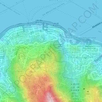
Name: Braemar Hill topographic map, elevation, terrain.
Location: Braemar Hill, Hong Kong Island, Hong Kong, 000000, China (22.28637 114.20639 22.28647 114.20649)
Average elevation: 89 m
Minimum elevation: 0 m
Maximum elevation: 388 m
Thank you for supporting this site ❤️
Make a donation
Make a donation
Other topographic maps
Click on a map to view its topography, its elevation and its terrain.