
Make a donation
Le Hingleuf topographic map
Click on the map to display elevation.
Make a donation
About this map
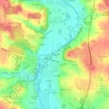
Name: Le Hingleuf topographic map, elevation, terrain.
Average elevation: 47 m
Minimum elevation: 12 m
Maximum elevation: 88 m
Make a donation
Other topographic maps
Click on a map to view its topography, its elevation and its terrain.
La Chapelle-Caro
France > Bretagne > Morbihan > Val d'Oust
Le relief de cette ancienne commune présente une pente générale vers l'ouest en direction de la vallée de l'Oust ; le dénivelé est notable entre le point le plus haut (116 mètres d'altitude) situé dans l'angle nord-est de son finage (au sud du lieu-dit La Boare) et la vallée de l'Oust (17 mètres…
Average elevation: 56 m
Le Roc-Saint-André
France > Bretagne > Morbihan > Val d'Oust
Le finage du Roc-Saint-André est constitué de deux parties très différentes : d'une part les trois quarts ouest de cette ancienne commune sont un plateau (formé de petites collines séparées par des ruisseaux qui vont se jeter dans l'Oust) situé en moyenne entre 80 mètres et 100 mètres d'altitude,…
Average elevation: 50 m