
Provence topographic map
Interactive map
Click on the map to display elevation.
About this map
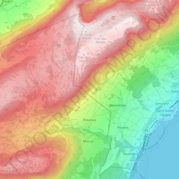
Name: Provence topographic map, elevation, terrain.
Location: Provence, District du Jura-Nord vaudois, Waadt, 1428, Schweiz (46.87235 6.63021 46.93609 6.74011)
Average elevation: 971 m
Minimum elevation: 422 m
Maximum elevation: 1,459 m
Zu Provence gehören die Hofsiedlungen Les Prises (920 m ü. M.) am Jurahang oberhalb des Dorfes und Les Rochats (1164 m ü. M.) am Südhang des Truchet sowie zahlreiche Einzelhöfe, die weit verstreut auf den Jurahöhen liegen. Die Nachbargemeinden von Provence sind im Südsüdosten Mutrux, im Süden Concise, im Südsüdwesten Bonvillars und im Südwesten Tévenon im Kanton Waadt sowie im Nordwesten und Norden Val-de-Travers und La Grande Béroche im Kanton Neuenburg.
Other topographic maps
Click on a map to view its topography, its elevation and its terrain.
Lignerolle
Schweiz > Waadt > District du Jura-Nord vaudois
Lignerolle, District du Jura-Nord vaudois, Waadt, 1357, Schweiz
Average elevation: 974 m
Le Lieu
Schweiz > Waadt > District du Jura-Nord vaudois
Le Lieu, District du Jura-Nord vaudois, Waadt, Schweiz
Average elevation: 1,170 m
Le Brassus
Schweiz > Waadt > District du Jura-Nord vaudois
Le Brassus, Le Chenit, District du Jura-Nord vaudois, Waadt, 1348, Schweiz
Average elevation: 1,152 m
Dent de Vaulion
Schweiz > Waadt > District du Jura-Nord vaudois > Vaulion
Dent de Vaulion, Vaulion, District du Jura-Nord vaudois, Waadt, 1325, Schweiz
Average elevation: 1,144 m
Le Chasseron
Schweiz > Waadt > District du Jura-Nord vaudois > Bullet
Le Chasseron, Bullet, District du Jura-Nord vaudois, Waadt, 1452, Schweiz
Average elevation: 1,367 m