
Thank you for supporting this site ❤️
Make a donation
Make a donation
Rudersdal Municipality topographic map
Click on the map to display elevation.
Thank you for supporting this site ❤️
Make a donation
Make a donation
About this map
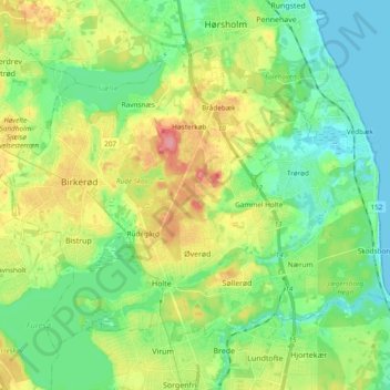
Name: Rudersdal Municipality topographic map, elevation, terrain.
Location: Rudersdal Municipality, Capital Region of Denmark, Denmark (55.79512 12.39279 55.87812 12.58231)
Average elevation: 31 m
Minimum elevation: 0 m
Maximum elevation: 89 m
Thank you for supporting this site ❤️
Make a donation
Make a donation
Other topographic maps
Click on a map to view its topography, its elevation and its terrain.
Thank you for supporting this site ❤️
Make a donation
Make a donation
Thank you for supporting this site ❤️
Make a donation
Make a donation
Thank you for supporting this site ❤️
Make a donation
Make a donation
Thank you for supporting this site ❤️
Make a donation
Make a donation
Thank you for supporting this site ❤️
Make a donation
Make a donation
Thank you for supporting this site ❤️
Make a donation
Make a donation
Thank you for supporting this site ❤️
Make a donation
Make a donation
Thank you for supporting this site ❤️
Make a donation
Make a donation
Thank you for supporting this site ❤️
Make a donation
Make a donation
Thank you for supporting this site ❤️
Make a donation
Make a donation
Thank you for supporting this site ❤️
Make a donation
Make a donation
Thank you for supporting this site ❤️
Make a donation
Make a donation
Thank you for supporting this site ❤️
Make a donation
Make a donation
Thank you for supporting this site ❤️
Make a donation
Make a donation
Store Havelse Strand
Denmark > Capital Region of Denmark > Ølsted Sydstrand > Store Havelse Strand
Average elevation: 11 m
Thank you for supporting this site ❤️
Make a donation
Make a donation