
Make a donation
Castle Cary topographic map
Click on the map to display elevation.
Make a donation
About this map
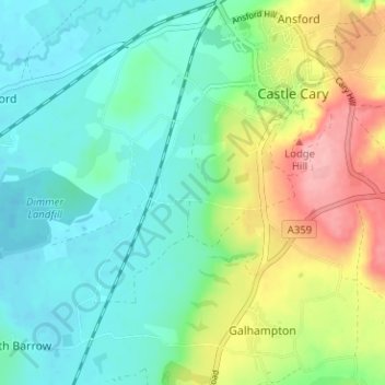
Name: Castle Cary topographic map, elevation, terrain.
Location: Castle Cary, Somerset, England, United Kingdom (51.05878 -2.55493 51.09837 -2.50503)
Average elevation: 68 m
Minimum elevation: 29 m
Maximum elevation: 156 m
Make a donation
Other topographic maps
Click on a map to view its topography, its elevation and its terrain.
Chard
United Kingdom > England > Somerset
Chard is a town and a civil parish in the English county of Somerset. It lies on the A30 road near the Devon and Dorset borders, 15 miles (24 km) south west of Yeovil. The parish has a population of approximately 13,000 and, at an elevation of 121 metres (397 ft), Chard is the southernmost and one of the…
Average elevation: 135 m
Make a donation
Make a donation
Make a donation
Make a donation
Wales
United Kingdom > England > Somerset > South Somerset > West Camel > Wales
Average elevation: 34 m
Make a donation
Make a donation
Make a donation
Make a donation
Make a donation
Make a donation
Make a donation
Make a donation
Make a donation
Make a donation
Small Brook
United Kingdom > England > Somerset > South Somerset > Haselbury Plucknett
Average elevation: 48 m
Hill End
United Kingdom > England > Somerset > South Somerset > Hardington Mandeville > Hill End
Average elevation: 62 m
St. Michael's Tower
United Kingdom > England > Somerset > Mendip District > Glastonbury
Average elevation: 33 m
Make a donation
Make a donation
Make a donation
Make a donation
Make a donation
Make a donation
Make a donation
Make a donation
Make a donation
Make a donation
Make a donation