
Make a donation
Truckee topographic map
Click on the map to display elevation.
Make a donation
Truckee
Truckee is characterized by its dramatic topography set in the Sierra Nevada mountain range. The town sits at an elevation of approximately 5,817 feet (1,774 meters), surrounded by a stunning landscape of rugged mountains, rolling hills, and expansive forested areas. Prominent features include Donner Pass, which is a significant historical and geographical landmark, and Donner Lake, a picturesque body of water nestled among the peaks. The terrain is diverse, offering steep slopes and high-altitude trails, which are popular for hiking, biking, and skiing, particularly in winter when the region is blanketed in snow. The unique combination of elevation and natural beauty makes Truckee a prime location for outdoor enthusiasts and those seeking scenic vistas year-round.
Make a donation
About this map
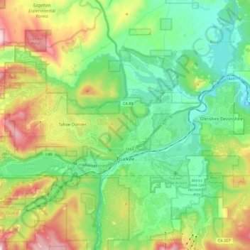
Name: Truckee topographic map, elevation, terrain.
Location: Truckee, Nevada County, California, United States (39.31616 -120.30160 39.38733 -120.07730)
Average elevation: 1,918 m
Minimum elevation: 1,661 m
Maximum elevation: 2,480 m
Make a donation
Other topographic maps
Click on a map to view its topography, its elevation and its terrain.
Make a donation
Make a donation
Make a donation
Make a donation
Make a donation