
Peterzell topographic map
Interactive map
Click on the map to display elevation.
About this map
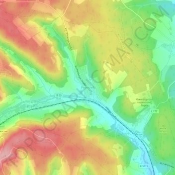
Name: Peterzell topographic map, elevation, terrain.
Average elevation: 836 m
Minimum elevation: 767 m
Maximum elevation: 910 m
Other topographic maps
Click on a map to view its topography, its elevation and its terrain.
Langenschiltach
Deutschland > Baden-Württemberg > Schwarzwald-Baar-Kreis > St. Georgen im Schwarzwald > Langenschiltach
Langenschiltach, St. Georgen im Schwarzwald, Schwarzwald-Baar-Kreis, Baden-Württemberg, 78112, Deutschland
Average elevation: 852 m