
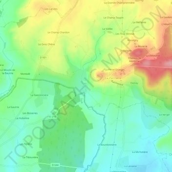
Le Champu topographic map
Interactive map
Click on the map to display elevation.
About this map
Name: Le Champu topographic map, elevation, terrain.
Average elevation: 156 m
Minimum elevation: 107 m
Maximum elevation: 236 m
Other topographic maps
Click on a map to view its topography, its elevation and its terrain.
Les Batailles
France > Normandie > Orne > Belforêt-en-Perche
Les Batailles, Le Gué-de-la-Chaîne, Belforêt-en-Perche, Mortagne-au-Perche, Orne, Normandie, France métropolitaine, 61130, France
Average elevation: 184 m
Bouvigny
France > Normandie > Orne > Belforêt-en-Perche
Bouvigny, La Perrière, Belforêt-en-Perche, Mortagne-au-Perche, Orne, Normandie, France métropolitaine, 61360, France
Average elevation: 179 m
Beau Repos
France > Normandie > Orne > Belforêt-en-Perche
Beau Repos, Eperrais, Belforêt-en-Perche, Mortagne-au-Perche, Orne, Normandie, France métropolitaine, 61400, France
Average elevation: 180 m
Eperrais
France > Normandie > Orne > Belforêt-en-Perche
Eperrais, Belforêt-en-Perche, Mortagne-au-Perche, Orne, Normandie, France métropolitaine, 61400, France
Average elevation: 189 m
Sérigny
France > Normandie > Orne > Belforêt-en-Perche
Sérigny, Belforêt-en-Perche, Mortagne-au-Perche, Orne, Normandie, France métropolitaine, 61130, France
Average elevation: 196 m
La Petite Grange
France > Normandie > Orne > Belforêt-en-Perche
La Petite Grange, La Perrière, Belforêt-en-Perche, Mortagne-au-Perche, Orne, Normandie, France métropolitaine, 61360, France
Average elevation: 167 m
La Perrière
France > Normandie > Orne > Belforêt-en-Perche
La Perrière, Belforêt-en-Perche, Mortagne-au-Perche, Orne, Normandie, France métropolitaine, 61360, France
Average elevation: 174 m