Geolocate

Quezon City topographic map

Interactive map

Click on the map to display elevation.

Quezon City

Quezon City is characterized by a diverse topography that features a mix of flatlands, rolling hills, and elevated areas, particularly in the eastern and northern parts of the city. The elevation generally ranges from about 25 to 300 feet above sea level, with higher elevations found in areas like the La Mesa Ecopark, which serves as a significant natural reserve within the urban landscape. The terrain is primarily composed of alluvial plains, which are conducive to urban development but also interspersed with green spaces, such as parks and gardens, providing a balance between concrete structures and nature. The city's natural drainage is aided by several rivers and waterways, including the Tullahan River, which meanders through parts of Quezon City, contributing to both the scenic beauty and the challenges of urban flooding during the rainy season. Overall, Quezon City's varied topography not only influences its urban layout but also plays a crucial role in its ecology and climate.

About this map

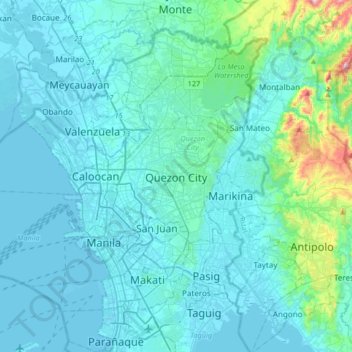
Name: Quezon City topographic map, elevation, terrain.

Location: Quezon City, Eastern Manila district, Metro Manila, Philippines (14.49080 120.88821 14.81080 121.20821)

Average elevation: 57 m

Minimum elevation: -3 m

Maximum elevation: 586 m

Other topographic maps

Click on a map to view its topography, its elevation and its terrain.

Panay

Philippines > Iloilo

Panay island is the sixth largest island in the Philippines by area, with a total land area of 12,011 km2 (4,637 sq mi). Mount Madja-as is the highest point in Panay with an elevation of 2,117 metres (6,946 ft) above sea level, located in town of Culasi in the northern province of Antique. Central Panay…

Average elevation: 117 m

Benguet

Philippines

The province suffers from crop damage resulting from seasonal frost during the cold months of December to March, especially in high-altitude towns such as Atok, Buguias, Mankayan and Kibungan. In February 2007, Benguet suffered crop damage due to temperatures reaching as low as 7 °C (45 °F).

Average elevation: 883 m

Boracay

Philippines > Aklan > Malay

Average elevation: 6 m

La Trinidad

Philippines > Benguet

The terrain is generally mountainous with springs, rivers and creeks. The town has a valley which encompasses several barangays. The valley floor elevation is at 1,300 metres (4,300 ft) above sea level. Elevation ranges from 500 to 1,700 metres (1,600 to 5,600 ft) above sea level.

Average elevation: 1,123 m

Ilocos Region

Philippines

The southern parts of the region were severely hit by the 1990 Luzon earthquake. Five municipalities in La Union were affected: Agoo, Aringay, Caba, Santo Tomas, and Tubao with a combined population of 132,208. Many buildings, including the Agoo Municipal hall, the Museo de Iloko, the parish church of Aringay,…

Average elevation: 219 m

Cagayan

Philippines

The eastern coast forms the northern portion of the Sierra Madre mountain range, while the western limits are generally hilly to low in elevation. The central area, dominated by a large valley, forms the lower basin of the country's longest river, the Cagayan. The mouth is located at the northern town of…

Average elevation: 110 m

San Miguel

Philippines > Bulacan

Average elevation: 36 m

Pililla

Philippines > Rizal

Average elevation: 80 m

Mataasnakahoy

Philippines > Batangas

Mataasnakahoy has 16 barangays and its total land area is 22.10 square kilometers (8.53 sq mi). It is bounded by Balete and Lipa City with Taal Lake on its western edge. The town is known for its cool climate due to its high elevation of 379 meters (1,243 ft).

Average elevation: 222 m

Freedom Park

Philippines > Marikina

Average elevation: 13 m

Banate

Philippines > Iloilo

Average elevation: 34 m

Cotabato City

Philippines

The city is situated in the lowest portion of Maguindanao province. The City of Cotabato with its 37 barangays spans an area with marked landscapes of flat, level to nearly level, very gently sloping to gently undulations to moderately sloping or rolling. It is basically a delta formed by two big rivers, the…

Average elevation: 65 m

Roxas

Philippines > Quezon City

Average elevation: 20 m

Subic Bay

Philippines > Bataan

Average elevation: 91 m

Mayag River

Philippines > Surigao Del Norte > Cantugas

Average elevation: 182 m

Silway River

Philippines > South Cotabato > Polomolok

Average elevation: 257 m

Baybay

Philippines > Leyte

The climate is of Coronas Climate type IV, which is generally wet with no particularly discernible seasons. Its topography is generally mountainous in the eastern portion as it slopes down west towards the shore line. Generally an agricultural city, the common means of livelihood are farming and fishing. Some…

Average elevation: 157 m

Camarines Norte

Philippines

Average elevation: 47 m

San Roque

Philippines > Batangas > Santo Tomas

Average elevation: 146 m

San Lorenzo

Philippines > Guimaras

Average elevation: 39 m

Caballo Island

Philippines > Cavite > Cavite City

Caballo Island (which means "Horse Island" in Spanish) is a bluff, rocky island located at the entrance to Manila Bay in the Philippines. It is about 1.2 km (0.75 mi) long with the highest elevation at 381 feet high. Caballo, along with the larger Corregidor (2 km to the north), divides the entrance to the bay…

Average elevation: 0 m

Camdas

Philippines > Baguio

Average elevation: 1,438 m

La Paz

Philippines > Negros Oriental > Bais

Average elevation: 15 m

Digkila-an

Philippines > Iligan

Average elevation: 151 m

Bessang Pass

Philippines > Ilocos Sur

Average elevation: 1,377 m

Peñaplata

Philippines > Davao del Norte > Samal

Average elevation: 27 m

Panaon Island

Philippines > Southern Leyte

Average elevation: 61 m

Libertad

Philippines > Antique

Average elevation: 66 m

Rizal

Philippines > Nueva Ecija

Average elevation: 120 m

Santa Teresita

Philippines > Batangas

Average elevation: 75 m

Pilar

Philippines > Capiz

Average elevation: 32 m

Sinocalan River

Philippines > Pangasinan > San Manuel

Average elevation: 354 m

Tapaz

Philippines > Capiz

Average elevation: 141 m

Cataning

Philippines > Bataan > Balanga

Average elevation: 11 m

Polomolok

Philippines > South Cotabato

Average elevation: 485 m

Daet River

Philippines > Camarines Norte > Daet > Bibirao

Average elevation: 19 m

Zapote

Philippines > Las Piñas

Average elevation: 6 m

Anabu II-C

Philippines > Cavite > Imus

Average elevation: 33 m

San Fernando

Philippines > Bukidnon

Average elevation: 665 m

Cainta, Rizal

Philippines > Rizal > Goldland Eastwood

Average elevation: 45 m

Isabela

Philippines

The province is divided into three physiographic areas. The eastern area, straddled by the Sierra Madre mountain range, is rugged and thickly forested. A substantial portion is uncharted. These unexplored hinterlands are home to a rich variety of flora and fauna, and some are under government reservations. It…

Average elevation: 227 m

Cantil-e

Philippines > Negros Oriental > Dumaguete

Average elevation: 77 m

Kayapa

Philippines > Nueva Vizcaya

Average elevation: 1,258 m

Alapan II-A

Philippines > Cavite > Imus

Average elevation: 12 m

Victorias

Philippines > Negros Occidental

Average elevation: 76 m

Tarlac River

Philippines > Tarlac

Average elevation: 43 m

Ciudad de Victoria

Philippines > Bulacan > Bocaue

Average elevation: 11 m

Magsaysay

Philippines > Occidental Mindoro

Magsaysay, one of the eleven municipalities in the Occidental Mindoro, lies on the southernmost part of Mindoro Island, and is adjacent to the municipality of San Jose on the north; on the east separated by chain of valleys and mountains in the municipality of Bulalacao, Oriental Mindoro; on the south, by…

Average elevation: 62 m

Paltok

Philippines > Quezon City

Average elevation: 25 m

Pasong Putik Proper

Philippines > Quezon City

Average elevation: 70 m

Muntingdilaw

Philippines > Rizal > Antipolo

Average elevation: 26 m

Morong Plaza

Philippines > Rizal > Morong > Morong

Average elevation: 13 m

Candaba

Philippines > Pampanga

Average elevation: 24 m

Balasan

Philippines > Iloilo

Average elevation: 42 m

Corong Beach

Philippines > Palawan > El Nido

Average elevation: 50 m

Leyte

Philippines > Leyte

Mahagnao Volcano Natural Park Located in Burauen, Leyte, about 66 km (41 mi) from Tacloban City, the Mahagnao Volcano Natural Park attracts visitors with its lakes, craters, hot springs, multi-colored mud, virgin forests and lagoon. It was proclaimed as a national park in 1937. Like other regions in the…

Average elevation: 68 m

Mayao Parada

Philippines > Lucena

Average elevation: 10 m

Bukidnon

Philippines

Situated within Bukidnon is Mount Dulang-dulang, the 2nd highest mountain in the country, with an elevation of 2,938 metres (9,639 ft) located in the Kitanglad Mountain Range. Mount Kitanglad (2,899 m), Mount Kalatungan (2,860 m), Mount Maagnaw (2,742 m), Mount Lumuluyaw (2,612 m), and Mount Tuminungan (2,400…

Average elevation: 686 m

Capri

Philippines > Quezon City

Average elevation: 39 m

Anini-y

Philippines > Antique

Average elevation: 13 m

Burgos Circle Park

Philippines > Taguig

Average elevation: 24 m

Diguisit Beach

Philippines > Aurora > Baler

Average elevation: 40 m

Gerona

Philippines > Tarlac

Average elevation: 28 m

Bahay Pare

Philippines > Pampanga > Candaba

Average elevation: 10 m

Calbayog

Philippines > Samar

Average elevation: 78 m

Isabela

Philippines > Basilan

The elevation of Isabela to 4th-class city status gave the local government a much-needed boost, efficiently delivered under the Biel administration, revitalized Isabela City, making it an engine of growth for Basilan province even as the hinterlands was wracked by incessant firefights and gun-battles between…

Average elevation: 93 m

Caba

Philippines > La Union

Average elevation: 61 m

Lawa

Philippines > Laguna > Calamba

Average elevation: 32 m

Cavite City

Philippines > Cavite

Average elevation: 53 m

Bagong Nayon

Philippines > Rizal > Antipolo

Average elevation: 165 m

Pamilacan Island

Philippines > Bohol > Pamilacan

Average elevation: 2 m

Marilag

Philippines > Quezon City

Average elevation: 42 m

Padada

Philippines > Davao del Sur

Average elevation: 29 m

Bakakeng Central

Philippines > Baguio

Average elevation: 1,409 m

Pulilan

Philippines > Bulacan

The municipality is generally of flat topography. Eleven (11) of its barangays are bounded by the Angat River. The rest are flat irrigated rice lands. Soil types vary from sandy loam to clay loam which makes the municipality suitable to a wide range of agricultural products.

Average elevation: 10 m

Del Gallego

Philippines > Camarines Sur

Average elevation: 91 m

Poblacion, Calamba

Philippines > Laguna > Calamba

Average elevation: 13 m

Barangay 1

Philippines > Laguna > Calamba

Average elevation: 21 m

Talisay

Philippines > Batangas

Average elevation: 128 m

Barangay 37

Philippines > Caloocan

Average elevation: 11 m

Fort Bonifacio

Philippines > Taguig

Average elevation: 19 m

Old Capitol Site

Philippines > Quezon City

Average elevation: 52 m

Baungon

Philippines > Bukidnon

Average elevation: 615 m

Talipan

Philippines > Quezon > Pagbilao

Average elevation: 56 m

Lio Beach

Philippines > Palawan > El Nido > Villa Libertad

Average elevation: 13 m

Laiya-Ibabao

Philippines > Batangas > San Juan

Average elevation: 21 m

Dalig

Philippines > Rizal > Antipolo

Average elevation: 207 m

Kolambugan

Philippines > Lanao del Norte

Average elevation: 55 m

Loyola Heights

Philippines > Quezon City

Average elevation: 46 m

Santa Monica

Philippines > Quezon City

Average elevation: 47 m

Sibulan

Philippines > Negros Oriental

Average elevation: 217 m

Siargao

Philippines > Surigao Del Norte

Average elevation: 11 m