
Greater Poland Voivodeship topographic map
Interactive map
Click on the map to display elevation.
Greater Poland Voivodeship
The highest elevation is Greater Kobyla Mountain (284 m) in the Ostrzeszowski Hills, the lowest area is located in the valley of the Warta River at the mouth of its tributary the Noteć (21 m) in the north-western part of the region. Agriculturally fertile soils account for around 60% of the province's area, while 20%, the rest of the non-forested or urban areas, is mostly wetland soil (muck-peat and alluvial soils).
About this map
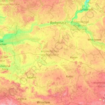
Name: Greater Poland Voivodeship topographic map, elevation, terrain.
Location: Greater Poland Voivodeship, Poland (51.10378 15.77629 53.65587 19.10502)
Average elevation: 110 m
Minimum elevation: 12 m
Maximum elevation: 372 m
Other topographic maps
Click on a map to view its topography, its elevation and its terrain.