
Thank you for supporting this site ❤️
Make a donation
Make a donation
Hünningen topographic map
Click on the map to display elevation.
Thank you for supporting this site ❤️
Make a donation
Make a donation
About this map
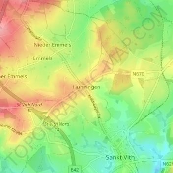
Name: Hünningen topographic map, elevation, terrain.
Location: Hünningen, Saint-Vith, Verviers, Liège, Wallonie, 4780, Belgique (50.27667 6.09369 50.31667 6.13369)
Average elevation: 497 m
Minimum elevation: 442 m
Maximum elevation: 563 m
Thank you for supporting this site ❤️
Make a donation
Make a donation
Other topographic maps
Click on a map to view its topography, its elevation and its terrain.