
Baar topographic map
Interactive map
Click on the map to display elevation.
About this map
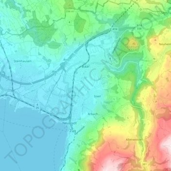
Name: Baar topographic map, elevation, terrain.
Location: Baar, Zug, Schweiz (47.15087 8.49602 47.22324 8.57775)
Average elevation: 534 m
Minimum elevation: 411 m
Maximum elevation: 928 m
Der Ortsname ist 1045 als Barra ersterwähnt. Er geht auf die keltische Siedlung auf der Baarburg zurück und bedeutet ‹Spitze, Anhöhe›.
Other topographic maps
Click on a map to view its topography, its elevation and its terrain.