
Make a donation
Austin topographic map
Click on the map to display elevation.
Make a donation
Austin
Austin is an unincorporated small town in, and former county seat of, Lander County, Nevada, United States. In 2020, the census-designated place of Austin had a population of 167. It is located on the western slopes of the Toiyabe Range at an elevation of 6,575 feet (2,004 m). U.S. Route 50 passes through the town.
Make a donation
About this map
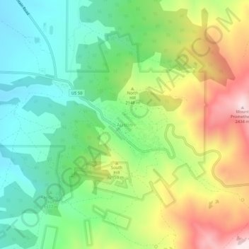
Name: Austin topographic map, elevation, terrain.
Location: Austin, Lander County, Nevada, United States (39.47299 -117.09145 39.51299 -117.05145)
Average elevation: 2,061 m
Minimum elevation: 1,834 m
Maximum elevation: 2,465 m
Make a donation
Other topographic maps
Click on a map to view its topography, its elevation and its terrain.
Battle Mountain
United States > Nevada > Lander County > Battle Mountain
Battle Mountain's climate is cool semi-arid (Köppen climate classification BSk), receiving just enough precipitation to avoid arid classification. Due to aridity and high elevation, the area commonly experiences large diurnal temperature variation, particularly in summer, when it averages almost 45 °F or 25…
Average elevation: 1,378 m
Battle Mountain
United States > Nevada > Lander County
Battle Mountain's climate is cool semi-arid (Köppen climate classification BSk), receiving just enough precipitation to avoid arid classification. Due to aridity and high elevation, the area commonly experiences large diurnal temperature variation, particularly in summer, when it averages almost 45 °F or 25…
Average elevation: 1,376 m