
Thank you for supporting this site ❤️
Make a donation
Make a donation
Syange topographic map
Click on the map to display elevation.
Thank you for supporting this site ❤️
Make a donation
Make a donation
About this map
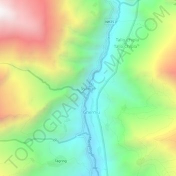
Name: Syange topographic map, elevation, terrain.
Location: Syange, Marsyangdi, Lamjung, Gandaki Province, Nepal (28.36727 84.38205 28.40727 84.42205)
Average elevation: 1,714 m
Minimum elevation: 1,042 m
Maximum elevation: 2,794 m
Thank you for supporting this site ❤️
Make a donation
Make a donation
Other topographic maps
Click on a map to view its topography, its elevation and its terrain.