
Make a donation
Quebradillas topographic map
Click on the map to display elevation.
Make a donation
Quebradillas
Quebradillas, located in the Northern Karst, borders on the Atlantic Ocean, is north of San Sebastián; east of Isabela, and west of Camuy. Quebradillas is home to one of the 20 designated forest preserves in Puerto Rico, the Guajataca State Forest. The forest serves as a great example of an unusual topography known as karst country. Karst is characterized by dissolved limestone formations such as sinkholes and haystack-shaped hills known as "mogotes". It is also home to the beautiful man-made reservoir, Guajataca Lake (2.5 mi or 4.0 km long), where you can fish for largemouth bass, peacock bass, tilapia and bluegill (in Spanish known as "chopa"). You can also go hiking or camping. The Puerto Rico Council of the Boy Scouts of America maintains a campground on the lake known as Camp Guajataka. The name Guajataca comes from the name Wahataka, a Taíno chief who lived in this area. This Indian chief also gives his name to Guajataca Beach to the north where Río Guajataca flowing from Guajataca Lake meets the Atlantic Ocean. Guajataca Beach is popular with surfers and is known for its white sands and wild waves. This beach is ideal for sunning and collecting seashells.
Make a donation
About this map
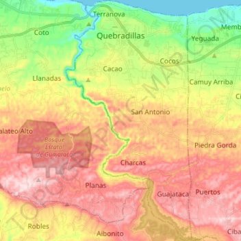
Name: Quebradillas topographic map, elevation, terrain.
Location: Quebradillas, Puerto Rico, United States (18.36571 -66.96857 18.49187 -66.89893)
Average elevation: 178 m
Minimum elevation: 0 m
Maximum elevation: 342 m
Make a donation
Other topographic maps
Click on a map to view its topography, its elevation and its terrain.
Make a donation
Make a donation
Make a donation
Isla de Mona
United States > Puerto Rico > Mayagüez
Mona is a mainly flat plateau surrounded by sea cliffs. It is composed of dolomite and limestone with many caves found throughout. With an arid climate and untouched by human development, many endemic species inhabit the island, such as the Mona ground iguana (Cyclura cornuta stejnegeri). Its topography,…
Average elevation: 26 m
Make a donation
Make a donation
Make a donation
Make a donation
Make a donation
Make a donation
Cayey
United States > Puerto Rico > Cayey
Cayey's climate is humid, rainy and mild compared to lower-elevation areas of the island, the area of the town is nearly 1,500 feet (460 m) high, so the climate is subtropical high. In summer average high Temperatures are around 82 °F to 88 °F and 70 °F to 78 °F in winter, and low around 68 °F to 72 °F…
Average elevation: 489 m
Make a donation
Gozalandia Waterfall
United States > Puerto Rico > San Sebastián > San Sebastián
Average elevation: 176 m
Make a donation
Make a donation
Make a donation
Ceiba
United States > Puerto Rico > Ceiba
The highest point in the municipality is Pico del Oeste in the Sierra de Luquillo at 3,346 feet (1,020 m) of elevation.
Average elevation: 50 m
Mayagüez
United States > Puerto Rico > Mayagüez
Mayagüez has a tropical monsoon climate (Köppen climate classification Am). The city has the most extreme weather of the island. The high frequency of severe storms in the summer can produce strong winds, floods, waterspouts, and sometimes hail and even tornadoes. The average annual temperature is 75 °F (24…
Average elevation: 93 m
Make a donation
Make a donation
Cerro de Punta
United States > Puerto Rico > Ponce
The mountain is part of the Cordillera Central and is located on the border between the municipalities of Jayuya and Ponce. The access road to the point closest to the highest elevation is from the municipality of Jayuya. It is part of the Toro Negro Forest Reserve, and it has been described as "an alpine…
Average elevation: 1,021 m
Make a donation
Make a donation
Villalba
United States > Puerto Rico > Villalba > Villalba
Villalba is located in the central region of Puerto Rico, on a valley in the Cordillera Central. The highest point in the municipality is Cerro El Bolo at 3,526 feet (1,075 m) of elevation.
Average elevation: 406 m
Make a donation
Make a donation
Make a donation