
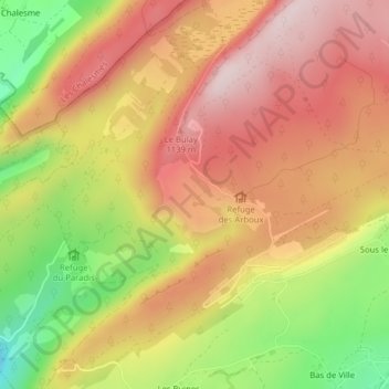
Les Arboux topographic map
Interactive map
Click on the map to display elevation.
About this map
Name: Les Arboux topographic map, elevation, terrain.
Average elevation: 1,004 m
Minimum elevation: 778 m
Maximum elevation: 1,165 m
Other topographic maps
Click on a map to view its topography, its elevation and its terrain.
Bas de Ville
France > Bourgogne-Franche-Comté > Jura > Foncine-le-Haut
Bas de Ville, Foncine-le-Haut, Lons-le-Saunier, Jura, Bourgogne-Franche-Comté, France métropolitaine, 39460, France
Average elevation: 958 m
Les Berthets
France > Bourgogne-Franche-Comté > Jura > Foncine-le-Haut
Les Berthets, Foncine-le-Haut, Lons-le-Saunier, Jura, Bourgogne-Franche-Comté, France métropolitaine, 39460, France
Average elevation: 999 m
Vers les Chalets
France > Bourgogne-Franche-Comté > Jura > Foncine-le-Haut
Vers les Chalets, Foncine-le-Haut, Lons-le-Saunier, Jura, Bourgogne-Franche-Comté, France métropolitaine, 39460, France
Average elevation: 1,015 m