
Thank you for supporting this site ❤️
Make a donation
Make a donation
Olgrinmore topographic map
Click on the map to display elevation.
Thank you for supporting this site ❤️
Make a donation
Make a donation
About this map
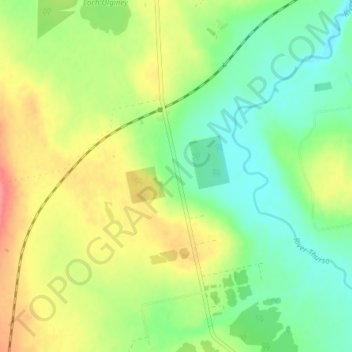
Name: Olgrinmore topographic map, elevation, terrain.
Location: Olgrinmore, Caithness, Scotland, KW12 6XJ, United Kingdom (58.45530 -3.56850 58.49530 -3.52850)
Average elevation: 71 m
Minimum elevation: 41 m
Maximum elevation: 114 m
Thank you for supporting this site ❤️
Make a donation
Make a donation
Other topographic maps
Click on a map to view its topography, its elevation and its terrain.