
Make a donation
Chadwick topographic map
Click on the map to display elevation.
Make a donation
About this map
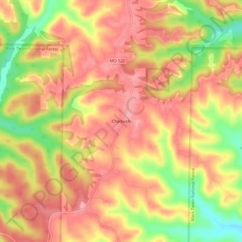
Name: Chadwick topographic map, elevation, terrain.
Location: Chadwick, Christian County, Missouri, 65629, United States (36.91006 -93.07684 36.95006 -93.03684)
Average elevation: 385 m
Minimum elevation: 314 m
Maximum elevation: 424 m
Make a donation
Other topographic maps
Click on a map to view its topography, its elevation and its terrain.
Highlandville
United States > Missouri > Christian County
A post office called Highlandville has been in operation since 1872. The city was named on account of its lofty elevation.
Average elevation: 385 m
Nixa
United States > Missouri > Christian County
Nixa Public Schools operates four elementary schools for students in kindergarten through fourth grade: Helen-Matthews Elementary, Espy Elementary, Century Elementary, and the newest, High Pointe Elementary (named because it sits on the highest elevation in Christian County), opened in August 2007. Two…
Average elevation: 380 m
Make a donation
Clever
United States > Missouri > Christian County
Clever is located on the Springfield Plateau of the Missouri Ozarks, 14.5 miles (23.3 km) southwest of Springfield at an elevation of 1,398 feet (426 m). The town lies in the western panhandle of Christian County, just south of Missouri Highway 14 between Nixa and Billings. The town of Republic and the…
Average elevation: 397 m
Make a donation