
Make a donation
Kinikinik topographic map
Click on the map to display elevation.
Make a donation
About this map
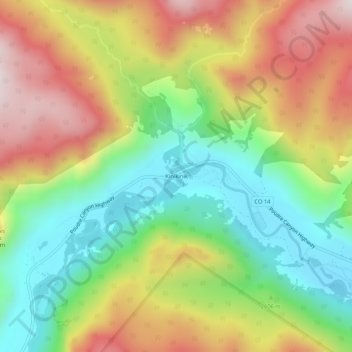
Name: Kinikinik topographic map, elevation, terrain.
Location: Kinikinik, Larimer County, Colorado, United States (40.69248 -105.75806 40.73248 -105.71806)
Average elevation: 2,641 m
Minimum elevation: 2,340 m
Maximum elevation: 3,020 m
Make a donation
Other topographic maps
Click on a map to view its topography, its elevation and its terrain.
Estes Park
United States > Colorado > Larimer County
Estes Park sits at an elevation of 7,522 feet (2,293 m) on the front range of the Rocky Mountains at the eastern entrance of the Rocky Mountain National Park. Its location is 40°22′22″N 105°31′09″W / 40.372856°N 105.519136°W / 40.372856; -105.519136. Its north, south and east extremities…
Average elevation: 2,409 m
Lake Estes
United States > Colorado > Larimer County > Estes Park > Stanley Heights Subdivision
Average elevation: 2,318 m
Make a donation
Rawah Wilderness
United States > Colorado > Larimer County
The Rawah Wilderness is administered by the USDA Forest Service. It is located on the Canyon Lakes Ranger District of the Roosevelt National Forest in Colorado, near the Wyoming border, and also in the Routt National Forest to its south. It encompasses 76,394 acres (309.16 km2) and includes 25 named lakes…
Average elevation: 2,898 m
Make a donation
Make a donation
Make a donation
Neota Wilderness
United States > Colorado > Larimer County
The Neota Wilderness is administered by the USDA Forest Service. It is located on the Canyon Lakes Ranger District of the Roosevelt National Forest in Colorado. This wilderness area encompasses 9,924 acres (40 km2) and is bordered on the south by Rocky Mountain National Park. Elevation ranges from 10,000 ft…
Average elevation: 3,254 m
Make a donation