
Thank you for supporting this site ❤️
Make a donation
Make a donation
Castro topographic map
Click on the map to display elevation.
Thank you for supporting this site ❤️
Make a donation
Make a donation
About this map
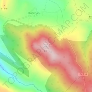
Name: Castro topographic map, elevation, terrain.
Location: Castro, Vinhais, Distrito de Bragança, Portugal (41.78272 -6.95116 41.78282 -6.95106)
Average elevation: 862 m
Minimum elevation: 653 m
Maximum elevation: 1,069 m
Thank you for supporting this site ❤️
Make a donation
Make a donation
Other topographic maps
Click on a map to view its topography, its elevation and its terrain.