
Laval topographic map
Interactive map
Click on the map to display elevation.
About this map
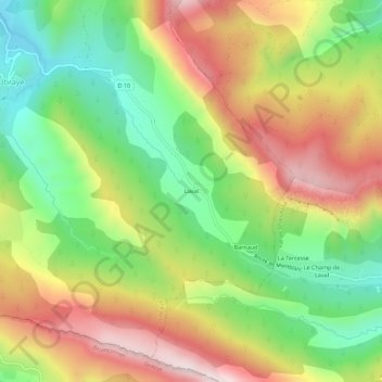
Name: Laval topographic map, elevation, terrain.
Average elevation: 1,209 m
Minimum elevation: 915 m
Maximum elevation: 1,553 m
Other topographic maps
Click on a map to view its topography, its elevation and its terrain.
Rouainette
France > Provence-Alpes-Côte d'Azur > Alpes-de-Haute-Provence > Ubraye > Rouainette
Rouainette, Ubraye, Castellane, Alpes-de-Haute-Provence, Provence-Alpes-Côte d'Azur, France métropolitaine, 04240, France
Average elevation: 1,133 m
Le Touyet
France > Provence-Alpes-Côte d'Azur > Alpes-de-Haute-Provence > Ubraye
Le Touyet, Ubraye, Castellane, Alpes-de-Haute-Provence, Provence-Alpes-Côte d'Azur, France métropolitaine, 04240, France
Average elevation: 1,266 m