
Thank you for supporting this site ❤️
Make a donation
Make a donation
Ferrel topographic map
Click on the map to display elevation.
Thank you for supporting this site ❤️
Make a donation
Make a donation
About this map
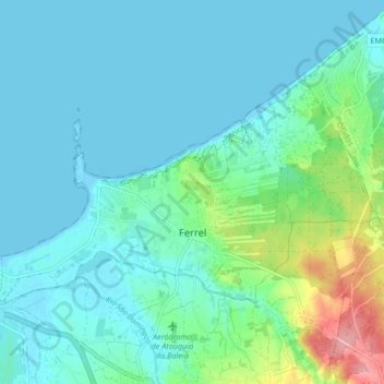
Name: Ferrel topographic map, elevation, terrain.
Location: Ferrel, Peniche, Leiria, Portugal (39.35120 -9.36056 39.39103 -9.27686)
Average elevation: 21 m
Minimum elevation: -2 m
Maximum elevation: 116 m
Thank you for supporting this site ❤️
Make a donation
Make a donation
Other topographic maps
Click on a map to view its topography, its elevation and its terrain.
Thank you for supporting this site ❤️
Make a donation
Make a donation
Thank you for supporting this site ❤️
Make a donation
Make a donation