
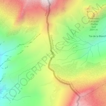
Col de la Seigne topographic map
Interactive map
Click on the map to display elevation.
About this map
Name: Col de la Seigne topographic map, elevation, terrain.
Location: Col de la Seigne, Courmayeur, Vallée d'Aoste, Italie (45.75121 6.80716 45.75131 6.80726)
Average elevation: 2,510 m
Minimum elevation: 2,054 m
Maximum elevation: 3,047 m
Other topographic maps
Click on a map to view its topography, its elevation and its terrain.
Villair Desot
Italie > Vallée d'Aoste > Courmayeur
Villair Desot, Courmayeur, Vallée d'Aoste, 11013, Italie
Average elevation: 1,613 m
Aiguille des Glaciers
Italie > Vallée d'Aoste > Courmayeur
Aiguille des Glaciers, Courmayeur, Vallée d'Aoste, Italie
Average elevation: 3,121 m
Col du Brouillard
Italie > Vallée d'Aoste > Courmayeur
Col du Brouillard, Courmayeur, Vallée d'Aoste, Italie
Average elevation: 2,911 m
Lac de Combal
Italie > Vallée d'Aoste > Courmayeur
Lac de Combal, Courmayeur, Vallée d'Aoste, Italie
Average elevation: 2,227 m
Larechon
Italie > Vallée d'Aoste > Courmayeur
Larechon, Courmayeur, Vallée d'Aoste, 11013, Italie
Average elevation: 1,928 m
Lex Blanche
Italie > Vallée d'Aoste > Courmayeur
Lex Blanche, Courmayeur, Vallée d'Aoste, Italie
Average elevation: 2,450 m
Pra Sec Damon
Italie > Vallée d'Aoste > Courmayeur
Pra Sec Damon, Courmayeur, Vallée d'Aoste, Italie
Average elevation: 2,108 m
Val Veny
Italie > Vallée d'Aoste > Courmayeur
Val Veny, Courmayeur, Vallée d'Aoste, Italie
Average elevation: 2,151 m
Le Pont
Italie > Vallée d'Aoste > Courmayeur
Le Pont, Courmayeur, Vallée d'Aoste, 11013, Italie
Average elevation: 2,012 m
Pussey
Italie > Vallée d'Aoste > Courmayeur
Pussey, Courmayeur, Vallée d'Aoste, 11013, Italie
Average elevation: 1,561 m
Larzey
Italie > Vallée d'Aoste > Courmayeur
Larzey, Courmayeur, Vallée d'Aoste, 11013, Italie
Average elevation: 1,596 m
Villair Damon
Italie > Vallée d'Aoste > Courmayeur
Villair Damon, Courmayeur, Vallée d'Aoste, 11013, Italie
Average elevation: 1,649 m
Lechey Desot
Italie > Vallée d'Aoste > Courmayeur
Lechey Desot, Courmayeur, Vallée d'Aoste, 11013, Italie
Average elevation: 1,814 m
Planpincieux
Italie > Vallée d'Aoste > Courmayeur
Planpincieux, Courmayeur, Vallée d'Aoste, 11013, Italie
Average elevation: 1,927 m
Arnuova Desot
Italie > Vallée d'Aoste > Courmayeur
Arnuova Desot, Courmayeur, Vallée d'Aoste, Italie
Average elevation: 2,222 m
Les Forges
Italie > Vallée d'Aoste > Courmayeur
Les Forges, Courmayeur, Vallée d'Aoste, 11013, Italie
Average elevation: 1,565 m
Entrelevie
Italie > Vallée d'Aoste > Courmayeur
Entrelevie, Courmayeur, Vallée d'Aoste, 11013, Italie
Average elevation: 1,588 m
Sécheron
Italie > Vallée d'Aoste > Courmayeur > Sécheron
Sécheron, Courmayeur, Vallée d'Aoste, Italie
Average elevation: 2,124 m
Ermitage
Italie > Vallée d'Aoste > Courmayeur > Ermitage
Ermitage, Courmayeur, Vallée d'Aoste, 11013, Italie
Average elevation: 1,660 m
Pic Eccles
Italie > Vallée d'Aoste > Courmayeur
Pic Eccles, Courmayeur, Vallée d'Aoste, Italie
Average elevation: 3,685 m
Grand Pilier d'Angle
Italie > Vallée d'Aoste > Courmayeur
Grand Pilier d'Angle, Courmayeur, Vallée d'Aoste, Italie
Average elevation: 3,780 m
Aiguille Blanche de Peuterey
Italie > Vallée d'Aoste > Courmayeur
Aiguille Blanche de Peuterey, Courmayeur, Vallée d'Aoste, Italie
Average elevation: 3,626 m
Col de Malatra
Italie > Vallée d'Aoste > Courmayeur
Col de Malatra, Sentiero Testa Bernarda, Corru, Courmayeur, Vallée d'Aoste, Italie
Average elevation: 2,739 m
Dôme du Goûter
Italie > Vallée d'Aoste > Courmayeur
Dôme du Goûter, Courmayeur, Vallée d'Aoste, Italie
Average elevation: 3,900 m
Pointe Baretti
Italie > Vallée d'Aoste > Courmayeur
Pointe Baretti, Courmayeur, Vallée d'Aoste, Italie
Average elevation: 3,443 m