
Irkeschtam topographic map
Interactive map
Click on the map to display elevation.
About this map
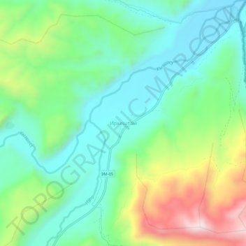
Name: Irkeschtam topographic map, elevation, terrain.
Location: Irkeschtam, Алай району, Gebiet Osch, Kirgisistan (39.65866 73.87881 39.69866 73.91881)
Average elevation: 2,988 m
Minimum elevation: 2,801 m
Maximum elevation: 3,404 m
Irkeschtam (kirgisisch/russisch Иркештам; nach anderen Umschriften Irkeshtam oder Irkeštam) ist ein Ort im kirgisischen Gebiet Osch, gelegen östlich des Alai-Tales unmittelbar vor der kirgisisch-chinesischen Grenze in 2940 m Höhe. Irkeschtam hat etwa 400 Einwohner.