
Takerbouzt topographic map
Interactive map
Click on the map to display elevation.
About this map
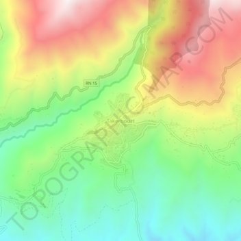
Name: Takerbouzt topographic map, elevation, terrain.
Location: Takerbouzt, Aghbalou, Daïra M'Chedallah, Bouira, 10007, Algérie (36.39980 4.32082 36.43980 4.36082)
Average elevation: 838 m
Minimum elevation: 448 m
Maximum elevation: 1,347 m
Other topographic maps
Click on a map to view its topography, its elevation and its terrain.
Selloum
Algérie > Bouira > Daïra M'Chedallah > Aghbalou
Selloum, Aghbalou, Daïra M'Chedallah, Bouira, 10007, Algérie
Average elevation: 759 m