
Thank you for supporting this site ❤️
Make a donation
Make a donation
Slater topographic map
Click on the map to display elevation.
Thank you for supporting this site ❤️
Make a donation
Make a donation
About this map
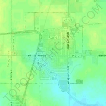
Name: Slater topographic map, elevation, terrain.
Location: Slater, Story County, Iowa, 50244, United States (41.86808 -93.69809 41.88885 -93.67360)
Average elevation: 316 m
Minimum elevation: 307 m
Maximum elevation: 323 m
Thank you for supporting this site ❤️
Make a donation
Make a donation
Other topographic maps
Click on a map to view its topography, its elevation and its terrain.