
Thank you for supporting this site ❤️
Make a donation
Make a donation
Bordeaux topographic map
Click on the map to display elevation.
Thank you for supporting this site ❤️
Make a donation
Make a donation
About this map
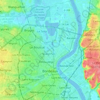
Name: Bordeaux topographic map, elevation, terrain.
Average elevation: 18 m
Minimum elevation: -4 m
Maximum elevation: 76 m
Thank you for supporting this site ❤️
Make a donation
Make a donation
Other topographic maps
Click on a map to view its topography, its elevation and its terrain.
Château Cos d'Estournel
France > Nouvelle-Aquitaine > Gironde > Saint-Estèphe > Cos
Average elevation: 14 m
Ancienne Abbaye de la Sauve-Majeure
France > Nouvelle-Aquitaine > Gironde > La Sauve
Average elevation: 90 m
Thank you for supporting this site ❤️
Make a donation
Make a donation
Thank you for supporting this site ❤️
Make a donation
Make a donation
Thank you for supporting this site ❤️
Make a donation
Make a donation
Château Coutet
France > Nouvelle-Aquitaine > Gironde > Saint-Émilion > Pourret
Average elevation: 45 m
Thank you for supporting this site ❤️
Make a donation
Make a donation
Thank you for supporting this site ❤️
Make a donation
Make a donation
Thank you for supporting this site ❤️
Make a donation
Make a donation
Thank you for supporting this site ❤️
Make a donation
Make a donation
Pont-de-la-Beauze
France > Nouvelle-Aquitaine > Gironde > Saint-André-et-Appelles
Average elevation: 48 m