
Thank you for supporting this site ❤️
Make a donation
Make a donation
Zărnești topographic map
Click on the map to display elevation.
Thank you for supporting this site ❤️
Make a donation
Make a donation
About this map
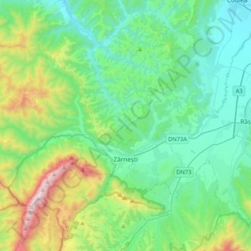
Name: Zărnești topographic map, elevation, terrain.
Location: Zărnești, Zona Metropolitană Brașov, Brașov, Romania (45.51969 25.10323 45.65557 25.40215)
Average elevation: 912 m
Minimum elevation: 541 m
Maximum elevation: 2,208 m
Thank you for supporting this site ❤️
Make a donation
Make a donation
Other topographic maps
Click on a map to view its topography, its elevation and its terrain.