Geolocate

Bhilwara topographic map

Interactive map

Click on the map to display elevation.

About this map

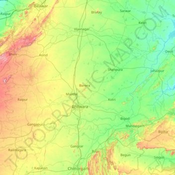
Name: Bhilwara topographic map, elevation, terrain.

Location: Bhilwara, Rajasthan, India (25.01403 74.01289 25.96374 75.46101)

Average elevation: 433 m

Minimum elevation: 303 m

Maximum elevation: 842 m

Other topographic maps

Click on a map to view its topography, its elevation and its terrain.

Chandoli

India > Rajasthan > Alwar Tehsil

Average elevation: 318 m

Brindawan

India > Rajasthan > Beejoliya Tehsil

Average elevation: 489 m

Ajmer

India > Rajasthan > Ajmer

Average elevation: 523 m

Pushkar

India > Rajasthan > Pushkar

Average elevation: 516 m

Chhabra

India > Rajasthan > Chhabra

Average elevation: 337 m

Peeli

India > Rajasthan > Peeli

Average elevation: 209 m