
Thank you for supporting this site ❤️
Make a donation
Make a donation
Citrus County topographic map
Click on the map to display elevation.
Thank you for supporting this site ❤️
Make a donation
Make a donation
About this map
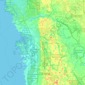
Name: Citrus County topographic map, elevation, terrain.
Location: Citrus County, Florida, United States (28.66567 -82.84825 29.05260 -82.16919)
Average elevation: 14 m
Minimum elevation: -1 m
Maximum elevation: 87 m
Thank you for supporting this site ❤️
Make a donation
Make a donation
Other topographic maps
Click on a map to view its topography, its elevation and its terrain.