
Thank you for supporting this site ❤️
Make a donation
Make a donation
Schlusser topographic map
Click on the map to display elevation.
Thank you for supporting this site ❤️
Make a donation
Make a donation
About this map
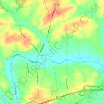
Name: Schlusser topographic map, elevation, terrain.
Location: Schlusser, Cumberland County, Pennsylvania, United States (40.22265 -77.19415 40.26371 -77.16405)
Average elevation: 142 m
Minimum elevation: 118 m
Maximum elevation: 168 m
Thank you for supporting this site ❤️
Make a donation
Make a donation