Geolocate

西坪镇 topographic map

Interactive map

Click on the map to display elevation.

About this map

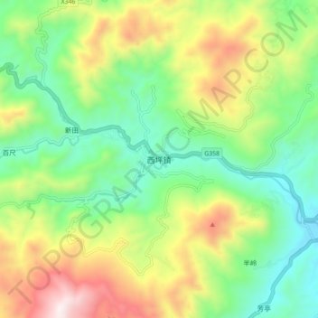
Name: 西坪镇 topographic map, elevation, terrain.

Location: 西坪镇, 安溪县, 泉州市, 福建省, 中国 (24.98358 117.90345 25.06358 117.98345)

Average elevation: 586 m

Minimum elevation: 195 m

Maximum elevation: 1,264 m

Other topographic maps

Click on a map to view its topography, its elevation and its terrain.

官桥镇

中国 > 福建省 > 安溪县

官桥镇, 安溪县, 泉州市, 福建省, 中国

Average elevation: 216 m

蓝田乡

中国 > 福建省 > 安溪县

蓝田乡, 安溪县, 泉州市, 福建省, 中国

Average elevation: 671 m

福都

中国 > 福建省 > 安溪县

福都, 安溪县, 泉州市, 福建省, 中国

Average elevation: 654 m

湖头镇

中国 > 福建省 > 安溪县

湖头镇, 安溪县, 泉州市, 福建省, 中国

Average elevation: 295 m

安溪县

中国 > 福建省 > 安溪县

安溪县, 泉州市, 福建省, 362400, 中国

Average elevation: 300 m

閩南

中国 > 福建省 > 安溪县 > 虎邱镇

閩南, 虎邱镇, 安溪县, 泉州市, 福建省, 中国

Average elevation: 376 m