
禹里镇 topographic map
Interactive map
Click on the map to display elevation.
About this map
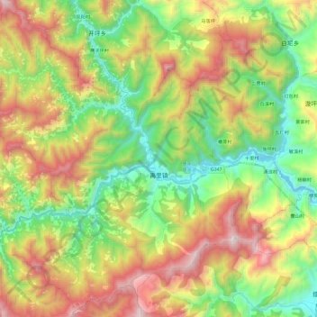
Name: 禹里镇 topographic map, elevation, terrain.
Location: 禹里镇, 北川羌族自治县, 绵阳市, 四川省, 中国 (31.77387 104.13968 31.96853 104.37183)
Average elevation: 1,338 m
Minimum elevation: 669 m
Maximum elevation: 2,327 m
禹里镇基本上为山地地形,海拔在750-2190米之间。
Other topographic maps
Click on a map to view its topography, its elevation and its terrain.