
Thank you for supporting this site ❤️
Make a donation
Make a donation
Oaks topographic map
Click on the map to display elevation.
Thank you for supporting this site ❤️
Make a donation
Make a donation
About this map
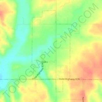
Name: Oaks topographic map, elevation, terrain.
Location: Oaks, Delaware County, Oklahoma, 74359, United States (36.15822 -94.85897 36.17983 -94.84585)
Average elevation: 321 m
Minimum elevation: 295 m
Maximum elevation: 344 m
Thank you for supporting this site ❤️
Make a donation
Make a donation
Other topographic maps
Click on a map to view its topography, its elevation and its terrain.