
Grunholz topographic map
Interactive map
Click on the map to display elevation.
About this map
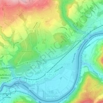
Name: Grunholz topographic map, elevation, terrain.
Average elevation: 381 m
Minimum elevation: 302 m
Maximum elevation: 548 m
Other topographic maps
Click on a map to view its topography, its elevation and its terrain.
Luttingen
Deutschland > Baden-Württemberg > Landkreis Waldshut > Laufenburg (Baden)
Luttingen, Laufenburg (Baden), Landkreis Waldshut, Baden-Württemberg, 79725, Deutschland
Average elevation: 383 m
Hochsal
Deutschland > Baden-Württemberg > Landkreis Waldshut > Laufenburg (Baden) > Hochsal
Hochsal, Laufenburg (Baden), Landkreis Waldshut, Baden-Württemberg, 79725, Deutschland
Average elevation: 445 m
Rhina
Deutschland > Baden-Württemberg > Landkreis Waldshut > Laufenburg (Baden)
Rhina, Laufenburg (Baden), Landkreis Waldshut, Baden-Württemberg, 79730, Deutschland
Average elevation: 375 m