
Thank you for supporting this site ❤️
Make a donation
Make a donation
Asolo topographic map
Click on the map to display elevation.
Thank you for supporting this site ❤️
Make a donation
Make a donation
About this map
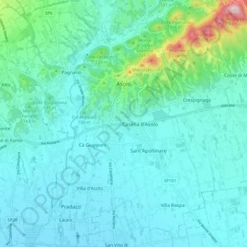
Name: Asolo topographic map, elevation, terrain.
Location: Asolo, Fonte, Province of Treviso, Veneto, 31011, Italy (45.75546 11.87468 45.82393 11.94839)
Average elevation: 132 m
Minimum elevation: 74 m
Maximum elevation: 460 m
Thank you for supporting this site ❤️
Make a donation
Make a donation
Other topographic maps
Click on a map to view its topography, its elevation and its terrain.
Thank you for supporting this site ❤️
Make a donation
Make a donation
Thank you for supporting this site ❤️
Make a donation
Make a donation
Thank you for supporting this site ❤️
Make a donation
Make a donation
Monte Pizzoc
Italy > Veneto > Province of Treviso > Fregona
Pizzoc is a mountain of the Veneto, Italy. It has an elevation of 1,565 metres.
Average elevation: 1,240 m
Sant'Andrea oltre il Muson
Italy > Veneto > Province of Treviso > Castelfranco Veneto
Average elevation: 38 m
Thank you for supporting this site ❤️
Make a donation
Make a donation