
Alausí topographic map
Interactive map
Click on the map to display elevation.
About this map
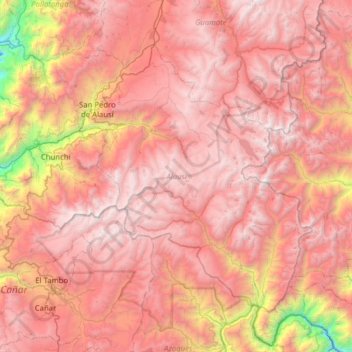
Name: Alausí topographic map, elevation, terrain.
Location: Alausí, Chimborazo, Équateur (-2.56733 -79.09107 -2.08275 -78.46211)
Average elevation: 3,276 m
Minimum elevation: 993 m
Maximum elevation: 4,606 m
Other topographic maps
Click on a map to view its topography, its elevation and its terrain.
Navac
Équateur > Chimborazo > Colta > Columbe
Navac, Columbe, Colta, Chimborazo, Équateur
Average elevation: 1,774 m