
Quảng Nam Province topographic map
Interactive map
Click on the map to display elevation.
About this map
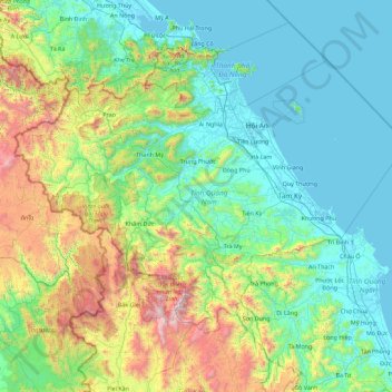
Name: Quảng Nam Province topographic map, elevation, terrain.
Location: Quảng Nam Province, Vietnam (14.95135 107.21092 16.16632 109.02356)
Average elevation: 464 m
Minimum elevation: -2 m
Maximum elevation: 2,536 m
Quảng Nam comprises flat land along the coast and increasingly high elevations towards the west, with the highest elevations along the border to Laos and Kon Tum province. The highest peak is Ngọc Linh mountain at 2598m. In contrast to the other provinces of the South Central Coast there are no hills or mountains near the coast (with the exception of the Chàm Islands with a peak of 517m).
Other topographic maps
Click on a map to view its topography, its elevation and its terrain.
Hue
Vietnam > Thừa Thiên Huế Province > Hue City > Hue
Hue, Hue City, Thừa Thiên Huế Province, 54000, Vietnam
Average elevation: 31 m
Hải Lăng District
Vietnam > Quang Tri province > Hải Lăng District
Hải Lăng District, Quang Tri province, Vietnam
Average elevation: 28 m
Kiến Giang
Vietnam > Quang Binh province > Kiến Giang
Kiến Giang, Lệ Thủy District, Quang Binh province, Vietnam
Average elevation: 3 m
Ho Chi Minh City
Vietnam > Ho Chi Minh City > Ho Chi Minh City
Ho Chi Minh City, District 1, Ho Chi Minh City, 00084, Vietnam
Average elevation: 6 m
Phú Bài
Vietnam > Thừa Thiên-Huế Province > Phú Bài
Phú Bài, Hương Thủy, Thừa Thiên-Huế Province, Vietnam
Average elevation: 13 m
Cần Giờ
Vietnam > Ho Chi Minh City > Ho Chi Minh City > Đông Hòa
Cần Giờ, Đông Hòa, Can Gio District, Ho Chi Minh City, Vietnam
Average elevation: 1 m
Ngoc Hien District
Ngoc Hien District, Ca Mau province, Vietnam
Average elevation: 1 m
Phu Quoc Island
Phu Quoc Island, Phu Quoc, Phu Quoc Island, Vietnam
Average elevation: 17 m
Tam Đường District
Tam Đường District, Lai Chau province, Vietnam
Average elevation: 1,312 m