
Thank you for supporting this site ❤️
Make a donation
Make a donation
Croeserw topographic map
Click on the map to display elevation.
Thank you for supporting this site ❤️
Make a donation
Make a donation
About this map
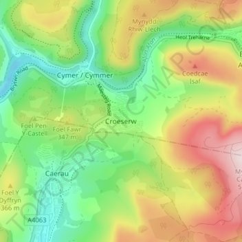
Name: Croeserw topographic map, elevation, terrain.
Location: Croeserw, Neath Port Talbot, Wales, SA13 3SP, United Kingdom (51.62464 -3.65840 51.66464 -3.61840)
Average elevation: 306 m
Minimum elevation: 133 m
Maximum elevation: 555 m
Thank you for supporting this site ❤️
Make a donation
Make a donation
Other topographic maps
Click on a map to view its topography, its elevation and its terrain.
Thank you for supporting this site ❤️
Make a donation
Make a donation
Thank you for supporting this site ❤️
Make a donation
Make a donation