Geolocate

Valka topographic map

Interactive map

Click on the map to display elevation.

About this map

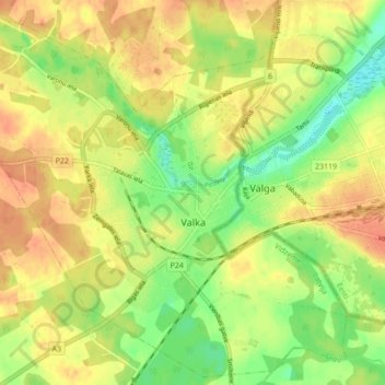
Name: Valka topographic map, elevation, terrain.

Location: Valka, Valkas novads, Vidzeme, LV-4701, Letland (57.75440 25.96422 57.79846 26.05053)

Average elevation: 61 m

Minimum elevation: 38 m

Maximum elevation: 76 m

Other topographic maps

Click on a map to view its topography, its elevation and its terrain.

Carnikavas novads

Letland > Vidzeme

Carnikavas novads, Vidzeme, LV-2163, Letland

Average elevation: 5 m

Siguldas novads

Letland > Vidzeme

Siguldas novads, Vidzeme, Letland

Average elevation: 107 m

Gaiziņkalns

Letland > Vidzeme

Gaiziņkalns, Madonas novads, Vidzeme, Letland

Average elevation: 250 m

Babītes novads

Letland > Vidzeme

Babītes novads, Vidzeme, Letland

Average elevation: 6 m

Jūrmala

Letland > Vidzeme

Jūrmala, Vidzeme, Letland

Average elevation: 4 m

Līgatnes novads

Letland > Vidzeme

Līgatnes novads, Vidzeme, Letland

Average elevation: 110 m