
Make a donation
Kokshetau topographic map
Click on the map to display elevation.
Make a donation
Kokshetau
It was the administrative center of Kokshetau Region (oblast) from 1944 to 1991 as part of the Soviet Union and from 1991 as part of Kazakhstan to 1997 when it was abolished. It is also situated at the junction of the Trans-Kazakhstan and South Siberian railways. Kokshetau lies at an elevation of approximately 234 m (768 ft) above sea level. The climate of Kokshetau features hot summers and cold winters.
Make a donation
About this map
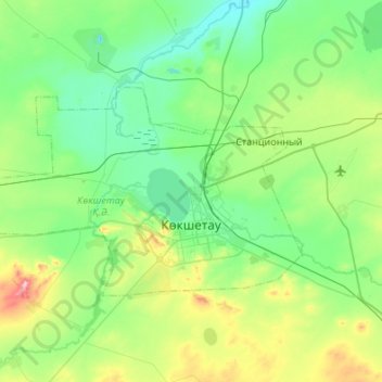
Name: Kokshetau topographic map, elevation, terrain.
Location: Kokshetau, Akmola Region, Kazakhstan (53.22496 68.99717 53.40154 69.53819)
Average elevation: 261 m
Minimum elevation: 199 m
Maximum elevation: 490 m
Make a donation
Other topographic maps
Click on a map to view its topography, its elevation and its terrain.
Kokshetau
It was the administrative center of Kokshetau Region (oblast) from 1944 to 1991 as part of the Soviet Union and from 1991 as part of Kazakhstan to 1997 when it was abolished. It is also situated at the junction of the Trans-Kazakhstan and South Siberian railways. Kokshetau lies at an elevation of approximately…
Average elevation: 248 m
Qorğaljın
Kazakhstan > Akmola Region > Qorğaljın district
The village is located on the Kazakh Uplands. The average altitude in the village is about 330 meters above sea level. The terrain is a continuous plain with small hills and water areas.
Average elevation: 330 m
Make a donation