
Make a donation
Rostock topographic map
Click on the map to display elevation.
Make a donation
About this map
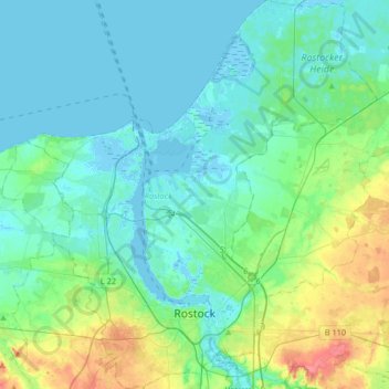
Name: Rostock topographic map, elevation, terrain.
Location: Rostock, Mecklenburg-Vorpommern, Germany (54.05081 11.99837 54.24450 12.29540)
Average elevation: 14 m
Minimum elevation: -4 m
Maximum elevation: 69 m
Make a donation
Other topographic maps
Click on a map to view its topography, its elevation and its terrain.
Make a donation
Heiligendamm
Germany > Mecklenburg-Vorpommern > Landkreis Rostock > Bad Doberan
Average elevation: 8 m
Make a donation
Bohnenwerder
Germany > Mecklenburg-Vorpommern > Mecklenburgische Seenplatte > Carwitz
Average elevation: 91 m
Make a donation
Valluhn
Germany > Mecklenburg-Vorpommern > Ludwigslust-Parchim > Lüttow-Valluhn
Average elevation: 32 m
Riemserort
Germany > Mecklenburg-Vorpommern > Vorpommern-Greifswald > Greifswald
Average elevation: 1 m
Greifswald
Germany > Mecklenburg-Vorpommern > Vorpommern-Greifswald > Greifswald > Greifswald
Average elevation: 6 m
Make a donation
Make a donation
Wismar
Germany > Mecklenburg-Vorpommern > Nordwestmecklenburg > Wismar > Wismar
Average elevation: 14 m
Löcknitz
Germany > Mecklenburg-Vorpommern > Vorpommern-Greifswald > Löcknitz > Löcknitz
Average elevation: 13 m
Bismark
Germany > Mecklenburg-Vorpommern > Vorpommern-Greifswald > Ramin > Bismark
Average elevation: 36 m
Make a donation