
Bos topographic map
Interactive map
Click on the map to display elevation.
About this map
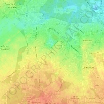
Name: Bos topographic map, elevation, terrain.
Average elevation: 29 m
Minimum elevation: 5 m
Maximum elevation: 48 m
Other topographic maps
Click on a map to view its topography, its elevation and its terrain.
Lignan
France > Nouvelle-Aquitaine > Gironde > Saint-Médard-en-Jalles
Lignan, Saint-Médard-en-Jalles, Bordeaux, Gironde, Nouvelle-Aquitaine, France métropolitaine, 33160, France
Average elevation: 44 m
Picot
France > Nouvelle-Aquitaine > Gironde > Saint-Médard-en-Jalles
Picot, Saint-Médard-en-Jalles, Bordeaux, Gironde, Nouvelle-Aquitaine, France métropolitaine, 33160, France
Average elevation: 37 m