
Thank you for supporting this site ❤️
Make a donation
Make a donation
Grezzana topographic map
Click on the map to display elevation.
Thank you for supporting this site ❤️
Make a donation
Make a donation
About this map
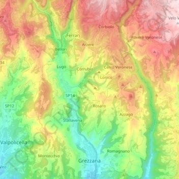
Name: Grezzana topographic map, elevation, terrain.
Location: Grezzana, Verona, Veneto, 37023, Italy (45.50739 10.97186 45.61584 11.07279)
Average elevation: 568 m
Minimum elevation: 139 m
Maximum elevation: 1,135 m
Thank you for supporting this site ❤️
Make a donation
Make a donation
Other topographic maps
Click on a map to view its topography, its elevation and its terrain.
Monte Pastello
Italy > Veneto > Verona > Fumane
Monte Pastello is a mountain of the Veneto, Italy. The mountain, which has an elevation of 1,128 metres, is part of the Monti Lessini in the Venetian Prealps. It is located in the Province of Verona.
Average elevation: 698 m
Thank you for supporting this site ❤️
Make a donation
Make a donation
Thank you for supporting this site ❤️
Make a donation
Make a donation
Thank you for supporting this site ❤️
Make a donation
Make a donation
Thank you for supporting this site ❤️
Make a donation
Make a donation
Thank you for supporting this site ❤️
Make a donation
Make a donation