
Thank you for supporting this site ❤️
Make a donation
Make a donation
Halma topographic map
Click on the map to display elevation.
Thank you for supporting this site ❤️
Make a donation
Make a donation
About this map
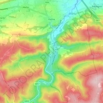
Name: Halma topographic map, elevation, terrain.
Location: Halma, Wellin, Neufchâteau, Luxemburg, Wallonië, 6922, België (50.02754 5.11509 50.08640 5.14769)
Average elevation: 297 m
Minimum elevation: 181 m
Maximum elevation: 420 m
Thank you for supporting this site ❤️
Make a donation
Make a donation