
El-Mesdour topographic map
Interactive map
Click on the map to display elevation.
About this map
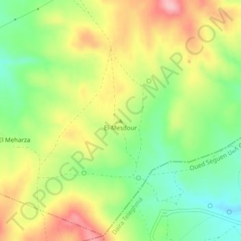
Name: El-Mesdour topographic map, elevation, terrain.
Location: El-Mesdour, Oued Athmania, Daïra Chelghoum Laïd, Mila, Algérie (36.18656 6.32420 36.18666 6.32430)
Average elevation: 841 m
Minimum elevation: 772 m
Maximum elevation: 920 m
Other topographic maps
Click on a map to view its topography, its elevation and its terrain.
Aïn Beida
Algérie > Mila > Daïra Chelghoum Laïd > Oued Athmania > Aïn Beida
Aïn Beida, Oued Athmania, Daïra Chelghoum Laïd, Mila, Algérie
Average elevation: 734 m