
Chez Chaussat topographic map
Interactive map
Click on the map to display elevation.
About this map
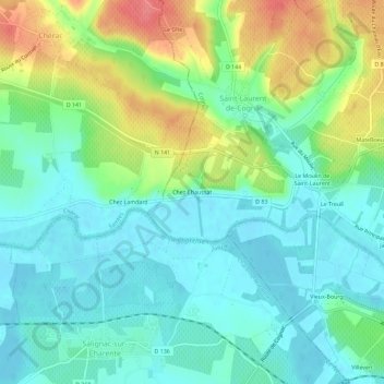
Name: Chez Chaussat topographic map, elevation, terrain.
Average elevation: 25 m
Minimum elevation: 1 m
Maximum elevation: 78 m
Other topographic maps
Click on a map to view its topography, its elevation and its terrain.
Le Moulin de Saint-Laurent
France > Nouvelle-Aquitaine > Charente > Saint-Laurent-de-Cognac
Le Moulin de Saint-Laurent, Saint-Laurent-de-Cognac, Cognac, Charente, Nouvelle-Aquitaine, France métropolitaine, 16100, France
Average elevation: 28 m