
Schlanstedt topographic map
Interactive map
Click on the map to display elevation.
About this map
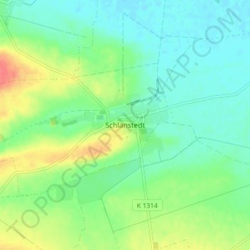
Name: Schlanstedt topographic map, elevation, terrain.
Average elevation: 98 m
Minimum elevation: 80 m
Maximum elevation: 133 m
Other topographic maps
Click on a map to view its topography, its elevation and its terrain.
Eilsdorf
Deutschland > Sachsen-Anhalt > Landkreis Harz > Huy
Eilsdorf, Huy, Landkreis Harz, Sachsen-Anhalt, 38838, Deutschland
Average elevation: 118 m
Badersleben
Deutschland > Sachsen-Anhalt > Landkreis Harz > Huy > Badersleben
Badersleben, Huy, Landkreis Harz, Sachsen-Anhalt, 38836, Deutschland
Average elevation: 179 m
Aderstedt
Deutschland > Sachsen-Anhalt > Landkreis Harz > Huy
Aderstedt, Huy, Landkreis Harz, Sachsen-Anhalt, 38838, Deutschland
Average elevation: 98 m