
Thank you for supporting this site ❤️
Make a donation
Make a donation
Calhoun topographic map
Click on the map to display elevation.
Thank you for supporting this site ❤️
Make a donation
Make a donation
About this map
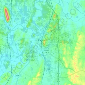
Name: Calhoun topographic map, elevation, terrain.
Location: Calhoun, Gordon County, Georgia, 30701, United States (34.42973 -84.98116 34.56758 -84.89026)
Average elevation: 210 m
Minimum elevation: 181 m
Maximum elevation: 355 m
Thank you for supporting this site ❤️
Make a donation
Make a donation
Other topographic maps
Click on a map to view its topography, its elevation and its terrain.