
Make a donation
Wilderswil topographic map
Click on the map to display elevation.
Make a donation
Wilderswil
The municipality extends for some 8 km (5.0 mi) from the village, along the west bank of the Lütschine river, and includes the flanks of the mountains that border that valley to the west. Its altitude ranges from some 580 m (1,900 ft), on the Bödeli plain, to 2,413 m (7,917 ft), at the summit of Sulegg. It consists of the villages of Wilderswil, Mülenen and Gsteigallmend.
Make a donation
About this map
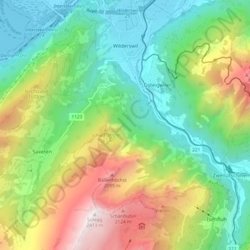
Name: Wilderswil topographic map, elevation, terrain.
Average elevation: 1,198 m
Minimum elevation: 557 m
Maximum elevation: 2,398 m
Make a donation
Other topographic maps
Click on a map to view its topography, its elevation and its terrain.
Titlis
Switzerland > Bern > Interlaken-Oberhasli administrative district > Innertkirchen
Average elevation: 2,520 m
Schilthorn
Switzerland > Bern > Interlaken-Oberhasli administrative district > Lauterbrunnen
Average elevation: 2,455 m
Burglauenen
Switzerland > Bern > Interlaken-Oberhasli administrative district > Grindelwald
Average elevation: 1,407 m
Brienz
Switzerland > Bern > Interlaken-Oberhasli administrative district > Brienz (BE)
Average elevation: 810 m
Make a donation
Ballenberg
Switzerland > Bern > Interlaken-Oberhasli administrative district > Hofstetten bei Brienz > Hofstetten
Average elevation: 774 m
Wellhorn
Switzerland > Bern > Interlaken-Oberhasli administrative district > Schattenhalb
Average elevation: 2,486 m